


Antiguo mapa náutico de Nueva Inglaterra de van Keulen, 1695: Cape Cod, Nantucket, Acadia (Nueva Escocia)
20% de descuento en 2 — 33% de descuento en 3
Añade dos artículos elegibles a tu carrito para recibir 20% de descuento. Añade un tercero y será complementario (equivalente a 33% de descuento al comprar tres).
No se necesita código — la oferta se aplica automáticamente al finalizar la compra.
Válido en todos los mapas estándar y impresiones de arte fino. Puedes mezclar y combinar cualquier diseño.
Si deseas enviar artículos a múltiples direcciones, por favor contáctanos antes de realizar tu pedido.
Las comisiones personalizadas y a medida están excluidas.
Contáctanos si tienes alguna pregunta
 Diseñado en Londres Hecho en Canada
Diseñado en Londres • Hecho en Canada
Diseñado en Londres Hecho en Canada
Diseñado en Londres • Hecho en Canada

Choose your size
Choose your finish


(Más información)
Mensaje de regalo y acabado personalizado

Si deseas agregar un mensaje de regalo, o un acabado (rompecabezas, tablero de aluminio, etc.) que no esté disponible aquí, por favor solicítalo en la "nota del pedido" cuando realices la compra.
Cada pedido es hecho a medida, así que si necesitas que el tamaño se ajuste ligeramente, o que se imprima en un material inusual, háznoslo saber. Hemos realizado miles de pedidos personalizados a lo largo de los años, así que hay (casi) nada que no podamos gestionar.
También puedes contactarnos antes de hacer tu pedido, ¡si lo prefieres!

- Made locally for fast, safe delivery
- No import duty or hidden fees
- Need advice? Message us on WhatsApp
Own a piece of history
7,000+ 5 star reviews


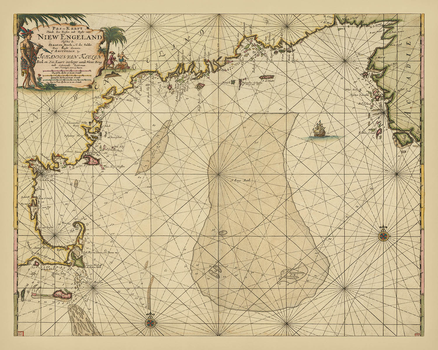
Adéntrese en la edad de oro de la exploración marítima con esta exquisita carta marina neerlandesa, «[Cape Cod to Acadia] Pas-Kaart Vande Zee Kusten inde boght van Niew Engeland Tusschen de Staaten Hoek en C.de Sable,» elaborada por el renombrado cartógrafo Johannes van Keulen en 1695. Esta notable carta náutica captura la intrincada costa de Nueva Inglaterra, desde las ventosas arenas de Cape Cod y la célebre isla de Nantucket, pasando por los bulliciosos puertos de Plymouth y Boston, hasta alcanzar las agrestes costas de Acadia (Nueva Escocia). Diseñada para el navegante exigente, este mapa es testimonio de la implacable búsqueda de precisión y detalle de la época, revelando las arterias marítimas que configuraron el temprano comercio transatlántico y la expansión colonial.
El foco principal del mapa recae en la geografía costera y los peligros de navegación de la fachada atlántica septentrional, representados meticulosamente mediante una serie de infografías que habrían sido indispensables para los marineros del siglo XVII. Los sondajes, indicados por grupos de números en brazas, trazan las profundidades cambiantes del mar, guiando a las naves con seguridad past arrecifes y bancos de arena traicioneros. La presencia de estos sondajes, junto con representaciones detalladas de corrientes, canales y obstrucciones submarinas, da cuenta de la utilidad práctica y del avanzado conocimiento hidrográfico plasmados en la obra de van Keulen.
Obra maestra del arte cartográfico neerlandés, esta carta se distingue además por su ornamentada rosa de los vientos y su cartela decorativa, rasgos distintivos de la casa editorial van Keulen. La rosa de los vientos no solo orienta al espectador, sino que también actúa como ancla visual, simbolizando la destreza náutica de los neerlandeses durante su edad de oro de la exploración. El elegante diseño del mapa, que combina precisión científica con florituras artísticas, refleja la tradición más amplia de los cartógrafos de Ámsterdam, quienes fijaron el estándar de la cartografía marítima en el siglo XVII.
Cada puerto nombrado, de Boston a Plymouth, y cada bajío o isla cuidadosamente trazados, narra una historia de riesgo, descubrimiento y la importancia vital de la información precisa en un mundo donde el mar era a la vez vía de comunicación y peligro. La inclusión de asentamientos costeros menos conocidos y la representación evolutiva de los bajíos—actualizada en ediciones sucesivas—demuestran la naturaleza dinámica de la cartografía de la temprana Edad Moderna, en la que las cartas eran documentos vivos, continuamente perfeccionados a medida que surgían nuevos conocimientos de los viajes que posibilitaban.
Poseer este mapa no es simplemente adquirir una pieza de historia marítima; es una invitación a seguir las rutas de los primeros exploradores y mercaderes, a apreciar la combinación de arte y ciencia que definió la tradición cartográfica neerlandesa, y a vislumbrar el mundo tal como apareció ante quienes primero trazaron estas aguas. Para coleccionistas y conocedores de mapas históricos, esta carta es un artefacto raro e imprescindible—un símbolo perdurable de exploración, artesanía y del eterno atractivo de lo desconocido.
Lugares destacados en este mapa
- Cape Cod (C. Cod)
- Isla de Nantucket (Natoket)
- Bahía de Boston
- Bahía de Plymouth
- Cape Sable (C. de Sable) en el extremo nororiental del mapa
- Varios asentamientos y puertos costeros sin nombre a lo largo de la costa de Nueva Inglaterra
- Bajíos y bancos de arena al suroeste de Nantucket y que se extienden desde Cape Sable
- La región general de Acadia (Nueva Escocia)
- Staaten Hoek (Staten Hook), que marca el extremo suroccidental del mapa
- Numerosas pequeñas islas y elementos costeros a lo largo de la línea de costa representada
Características destacadas y lugares de interés
- La costa de Nueva Inglaterra desde Cape Cod hasta Acadia (Nueva Escocia), con representaciones detalladas de bahías, ensenadas e islas
- Numerosas sondas (números que indican las profundidades del agua en brazas) distribuidas por las aguas costeras
- Bajos y bancos de arena representados, especialmente alrededor de Nantucket y Cape Cod, con nuevos bajos añadidos en ediciones posteriores
- Una gran y ornamentada rosa de los vientos para referencia de navegación
- Asentamientos costeros y puertos marcados, con algunos nombrados directamente en el mapa
- Cartucho decorativo y adornos típicos de las cartas marítimas holandesas de la época
- El mapa está orientado con el norte en la parte superior, como indica la rosa de los vientos
Contexto histórico y de diseño
- Elaborado por Johannes van Keulen, un destacado cartógrafo y editor neerlandés conocido por sus influyentes atlas y cartas náuticas a finales del siglo XVII y principios del XVIII
- Fecha de creación: 1695 (con ediciones anteriores publicadas por primera vez en 1684, y actualizaciones posteriores en 1687 y después)
- Una de las cartas costeras de Nueva Inglaterra más tempranas y detalladas que se pueden adquirir; considerada esencial para coleccionistas de cartografía regional e historia marítima
- La Zee-Fakkel de Johannes van Keulen fue un hito en la cartografía marítima, y sus cartas desempeñaron un papel clave en el desarrollo de la navegación y el comercio en el Atlántico Norte
- Típica de las cartas marítimas neerlandesas de finales del siglo XVII, con elementos decorativos, rosas de los vientos e información hidrográfica detallada para la navegación
- Entre los cambios más notables en las ediciones sucesivas figuran la adición de bajos, la numeración en las esquinas y actualizaciones de los elementos de navegación, reflejando la evolución del conocimiento de la costa
Por favor, compruebe las imágenes detenidamente para asegurarse de que aparece en este mapa una ciudad o lugar concreto. También puede ponerse en contacto con nosotros y pedirnos que lo verifiquemos por usted.
Este mapa luce великолепно en cualquier tamaño, pero siempre recomiendo optar por un tamaño mayor si dispone de espacio. Así podrá apreciar fácilmente todos los detalles.
Este mapa luce increíble en tamaños de hasta 100in (250cm). Si busca un mapa más grande, por favor póngase en contacto.
El modelo de las imágenes del anuncio está sosteniendo la versión de 16x20in (40x50cm) de este mapa.
La quinta imagen del anuncio muestra un ejemplo de mi servicio de personalización de mapas.
Si busca algo un poco diferente, eche un vistazo a mi colección de los mejores mapas antiguos para ver si algo más le llama la atención.
Por favor, póngase en contacto conmigo para comprobar si una determinada ubicación, lugar de interés o elemento aparece en este mapa.
Sería un maravilloso regalo de cumpleaños, Navidad, Día del Padre, despedida laboral, aniversario o inauguración de casa para alguien de las zonas cubiertas por este mapa.
Este mapa está disponible como impresión giclée sobre papel mate de archivo libre de ácido, o puede adquirirlo enmarcado. El marco es un bonito y sencillo marco negro que combina con la mayoría de estéticas. Por favor, póngase en contacto si desea un color o material de marco diferente. Mis marcos llevan un acristalamiento de acrílico de calidad museística de gran claridad (perspex/acrylite), que es significativamente menos reflectante que el vidrio, más seguro y siempre llegará en perfectas condiciones.
This map is also available as a float framed canvas, sometimes known as a shadow gap framed canvas or canvas floater. The map is printed on artist's cotton canvas and then stretched over a handmade box frame. We then "float" the canvas inside a wooden frame, which is available in a range of colours (black, dark brown, oak, antique gold and white). This is a wonderful way to present a map without glazing in front. See some examples of float framed canvas maps and explore the differences between my different finishes.
For something truly unique, this map is also available in "Unique 3D", our trademarked process that dramatically transforms the map so that it has a wonderful sense of depth. We combine the original map with detailed topography and elevation data, so that mountains and the terrain really "pop". For more info and examples of 3D maps, check my Unique 3D page.
Many of our maps and art prints are chosen as thoughtful gifts for homes, offices, studies and meaningful places.
Choose a framed option for the easiest ready-to-hang gift, or choose an unframed print if the recipient may prefer to select their own frame.
We make orders locally in 23 countries around the world, so gifts can often be produced close to the recipient. This helps them arrive faster, travel more safely, and avoid customs or import duty surprises.
- We can deliver directly to the recipient
- Framed pieces arrive ready to hang
- Unframed prints are carefully packed in a strong protective tube
- Almost every order is made locally, for faster, safer gifting
- 90-day returns give the recipient time to decide
If you are not sure what to choose, please contact us. We can help you pick the right map, size, finish or delivery option.
Para la mayoría de los pedidos, el tiempo de entrega es de aproximadamente 3 días laborables. Los productos personalizados y a medida tardan más, ya que tengo que hacer la personalización y enviártelo para su aprobación, lo cual suele tardar 1 o 2 días.
Tenga en cuenta que los pedidos enmarcados muy grandes suelen tardar más en fabricarse y entregarse.
Si necesitas que tu pedido llegue para una fecha determinada, por favor contáctame antes de hacer el pedido para que podamos encontrar la mejor manera de asegurarnos de que recibas tu pedido a tiempo.
Imprimo y enmarco mapas y obras de arte en 23 países alrededor del mundo. Esto significa que tu pedido se fabricará localmente, lo que reduce el tiempo de entrega y asegura que no se dañe durante el envío. Nunca pagarás aranceles de aduana o impuestos de importación, y pondremos menos CO2 en el aire.
Todos mis mapas y impresiones artísticas están bien empaquetados y enviados en un tubo resistente si no están enmarcados, o rodeados de espuma si están enmarcados.
Intento enviar todos los pedidos dentro de 1 o 2 días después de recibir tu pedido, aunque algunos productos (como mascarillas, tazas y bolsas de tela) pueden tardar más en fabricarse.
Si seleccionas Entrega Exprés al finalizar la compra, priorizaremos tu pedido y lo enviaremos por mensajería de 1 día (Fedex, DHL, UPS, Parcelforce).
La entrega al día siguiente también está disponible en algunos países (EE. UU., Reino Unido, Singapur, EAU), pero por favor intenta hacer tu pedido temprano en el día para que podamos enviarlo a tiempo.
Mi marco estándar es un marco de madera de fresno negro estilo galería. Es simple y tiene un aspecto bastante moderno. Mi marco estándar tiene alrededor de 20 mm (0.8 in) de ancho.
Utilizo acrílico super claro (perspex/acrylite) para el vidrio del marco. Es más ligero y seguro que el vidrio, y se ve mejor, ya que la reflectividad es menor.
Seis colores de marco estándar están disponibles de forma gratuita (negro, marrón oscuro, gris oscuro, roble, blanco y oro antiguo).El enmarcado y montaje/matizado personalizado está disponible si buscas algo diferente.
La mayoría de los mapas, arte e ilustraciones también están disponibles como un lienzo enmarcado. Utilizamos lienzo de algodón mate (no brillante), lo estiramos sobre un marco de madera de caja de origen sostenible, y luego 'flotamos' la pieza dentro de un marco de madera. El resultado final es bastante hermoso, y no hay cristal que se interponga.
Todos los marcos se proporcionan "listos para colgar", con una cuerda o soportes en la parte posterior. Los marcos muy grandes tendrán placas de colgar de alta resistencia y/o un listón de montaje. Si tienes alguna pregunta, por favor ponte en contacto.
Mira algunos ejemplos de mis mapas enmarcados y mapas en lienzo enmarcados.
Alternativamente, también puedo proporcionar mapas antiguos y obras de arte en lienzo, tablero de espuma, papel de algodón y otros materiales.
Si deseas enmarcar tu mapa o obra de arte tú mismo, por favor lee mi guía de tamaños primero.
Mis mapas son reproducciones de mapas originales de altísima calidad.
Obtengo mapas originales y raros de bibliotecas, casas de subastas y colecciones privadas de todo el mundo, los restauro en mi taller de Londres y luego uso tintas e impresoras giclée especializadas para crear hermosos mapas que lucen incluso mejor que el original.
Mis mapas están impresos en papel de archivo mate (no brillante) sin ácido que se siente de muy alta calidad y casi como una tarjeta. En términos técnicos, el peso/grosor del papel es de 10 mil/200 g/m². Es perfecto para enmarcar.
Imprimo con tintas pigmentadas Epson ultrachrome giclée UV resistentes a la decoloración, algunas de las mejores tintas que puedes encontrar.
yo también puedo hacer mapas sobre lienzo, trapo de algodón y otros materiales exóticos.
Obtenga más información sobre The Unique Maps Co..
Personalización de mapas
Si está buscando el regalo perfecto de aniversario o inauguración de la casa, puedo personalizar su mapa para hacerlo verdaderamente único. Por ejemplo, puedo agregar un mensaje corto, resaltar una ubicación importante o agregar el escudo de armas de su familia.
Las opciones son casi infinitas. Por favor mira mi página de personalización de mapas para ver algunos maravillosos ejemplos de lo que es posible.
Para pedir un mapa personalizado, seleccione "personalizar su mapa" antes de agregarlo a su carrito.
Ponerse en contacto si buscas personalizaciones y personalizaciones más complejas.
Envejecimiento del mapa
A lo largo de los años, los clientes me han preguntado cientos de veces si podían comprar un mapa que se viera uniforme. más viejo.
Bueno, ahora puedes hacerlo seleccionando Envejecido antes de agregar un mapa a tu carrito.
Todas las fotografías de productos que ve en esta página muestran el mapa en su forma original. Así es como se ve el mapa hoy.
Si selecciona Envejecido, envejeceré su mapa a mano, usando un proceso especial y único desarrollado a través de años de estudiar mapas antiguos, hablar con investigadores para comprender la química del envejecimiento del papel y, por supuesto... ¡mucha práctica!
Si no estás seguro, quédate con el color original del mapa. Si quieres algo un poco más oscuro y más viejo buscando, opte por Envejecido.
Si no estás satisfecho con tu pedido por cualquier motivo, contáctame para un reembolso sin complicaciones. Por favor, consulta nuestra política de devoluciones y reembolsos para más información.
Estoy muy seguro de que te gustará tu mapa o impresión artística restaurada. He estado haciendo esto desde 1984. Soy un vendedor de 5 estrellas en Etsy. He vendido decenas de miles de mapas e impresiones artísticas y tengo más de 5,000 opiniones reales de 5 estrellas.
Utilizo un proceso único para restaurar mapas y obras de arte que consume mucho tiempo y mano de obra. Buscar los mapas e ilustraciones originales puede llevar meses. Utilizo tecnología de última generación y extremadamente cara para escanear y restaurarlos. Como resultado, garantizo que mis mapas e impresiones artísticas son superiores a los demás - por eso puedo ofrecer un reembolso sin complicaciones.
Casi todos mis mapas e impresiones artísticas se ven increíbles en tamaños grandes (200cm, 6.5ft+) y también puedo enmarcarlos y entregártelos a través de un servicio de mensajería especial para tamaños grandes. Contáctame para discutir tus necesidades específicas.
Or try searching for something!


