


Rare Old Topographical Map of Germany, Poland & Switzerland by Bartholomew, 1955: Berlin, Warsaw, Zurich, Alps, Rhine
20% de descuento en 2 — 33% de descuento en 3
Añade dos artículos elegibles a tu carrito para recibir 20% de descuento. Añade un tercero y será complementario (equivalente a 33% de descuento al comprar tres).
No se necesita código — la oferta se aplica automáticamente al finalizar la compra.
Válido en todos los mapas estándar y impresiones de arte fino. Puedes mezclar y combinar cualquier diseño.
Si deseas enviar artículos a múltiples direcciones, por favor contáctanos antes de realizar tu pedido.
Las comisiones personalizadas y a medida están excluidas.
Contáctanos si tienes alguna pregunta
 Diseñado en Londres Hecho en Canada
Diseñado en Londres • Hecho en Canada
Diseñado en Londres Hecho en Canada
Diseñado en Londres • Hecho en Canada

Choose your size
Choose your finish


(Más información)
Mensaje de regalo y acabado personalizado

Si deseas agregar un mensaje de regalo, o un acabado (rompecabezas, tablero de aluminio, etc.) que no esté disponible aquí, por favor solicítalo en la "nota del pedido" cuando realices la compra.
Cada pedido es hecho a medida, así que si necesitas que el tamaño se ajuste ligeramente, o que se imprima en un material inusual, háznoslo saber. Hemos realizado miles de pedidos personalizados a lo largo de los años, así que hay (casi) nada que no podamos gestionar.
También puedes contactarnos antes de hacer tu pedido, ¡si lo prefieres!

- Made locally for fast, safe delivery
- No import duty or hidden fees
- Need advice? Message us on WhatsApp
Own a piece of history
7,000+ 5 star reviews


Originally titled “Germany, Poland and Switzerland” (Plate 62, Volume III), this 1955 chart from The Times Atlas of the World captures Central Europe at a decisive mid-century juncture. John Bartholomew’s hand is evident in the union of political clarity and physical drama: borders are crisply drawn while shaded relief and gentle gradient tints lift the Alps, Sudetes, and Black Forest from the page. Provinces and regions are labeled with scholarly precision, from Bavaria and Saxony to Silesia and Masovia, and the road network is color-keyed to anchor the great cities—Berlin, Hamburg, Munich, Warsaw, Kraków, Zurich, Geneva—within their landscapes. Rivers and lakes are traced with hydrological nuance, and maritime gradients fringe the North and Baltic seas, inviting both study and quiet admiration.
John Bartholomew, working through the Geographical Institute in Edinburgh, perfected a cartographic language that married elegance to exactitude. Here his relief shading, spot heights, and hypsometric tints articulate altitude as though illuminated by a slant of afternoon sun, while his typography balances density with legibility. The graticule is clean and navigationally frank, its reference to the Greenwich Prime Meridian grounding every coordinate. Distinctive color coding separates political boundaries from the arterial web of roads, a Bartholomew hallmark that serves scholars, students, and travelers alike. In the Mid-Century Edition, he distilled a complex continent into an intelligible whole—scientific in method, lucid in design, and imbued with a quiet, mid-century poise.
Germany unfolds as a study in contrasts—industrial heartlands, riverine corridors, and alpine ramparts—mapped with the finesse that made Bartholomew indispensable. The Rhine, Elbe, and Danube headwaters orient Frankfurt, Hamburg, and Munich, while the Bavarian Alps, Harz, Thuringian Forest, and Ore Mountains rise in sculpted relief. Postwar realities are legible without polemic: the delineation between the Federal Republic and the German Democratic Republic is exact, and Berlin’s special status is unmistakably marked. Länder names and urban hierarchies—Cologne, Stuttgart, Düsseldorf, Leipzig, Dresden—are set against a calibrated road network that threads the Ruhr to Bavaria and Saxony, showing how terrain channels movement. Along the North Sea, bathymetric tints and the Elbe estuary suggest mercantile pathways that have shaped Germany for centuries.
To the east, Poland’s broad plains and river-lattice receive an equally sensitive treatment. The Vistula cuts a commanding axis from Kraków through Warsaw to the Gulf of Gdańsk, while the Oder links Wrocław and Szczecin, underscoring the importance of waterways in settlement and trade. Bartholomew’s relief shading clarifies the arc of the Sudetes and the high shoulders of the Tatras and Beskids, and the map’s provincial labeling places Silesia, Greater Poland, Pomerania, and Masovia in immediate context. Along the Baltic, gradient blues step out into the Gulf of Gdańsk, while inland the Masurian lake country is delicately stippled. Clear voivodeship boundaries and carefully ranked city symbols—Łódź, Poznań, Gdańsk—convey a nation balancing historic regions with modern administration amid newly settled frontiers.
Switzerland provides a mountainous counterpoint, rendered with the luminous subtlety that Bartholomew reserved for high relief. The Alps surge in tonal bands from the Bernese Oberland to the Grisons, while the Jura scarp shadows the French frontier. Zurich, Geneva, Basel, Bern, Lausanne, and Lucerne are set beside the lucid waters of Lakes Geneva and Lucerne, with Lake Zurich and the Rhine’s headwaters precisely fixed by the graticule. Cantonal boundaries are etched with dignified restraint, reflecting a federal mosaic shaped by valleys, passes, and watersheds. North–south corridors and transalpine routes are suggested in the road network, emphasizing Switzerland’s role as a hinge of continental exchange. Throughout, the Greenwich-referenced coordinates and mid-century design clarity transform complex relief and borders into an enduring, navigable portrait of Central Europe.
Cities and towns on this map
- Berlin (Germany)
- Hamburg (Germany)
- Munich (Germany)
- Cologne (Germany)
- Frankfurt (Germany)
- Stuttgart (Germany)
- Düsseldorf (Germany)
- Leipzig (Germany)
- Dresden (Germany)
- Warsaw (Poland)
- Kraków (Poland)
- Łódź (Poland)
- Wrocław (Poland)
- Poznań (Poland)
- Gdańsk (Poland)
- Szczecin (Poland)
- Zurich (Switzerland)
- Geneva (Switzerland)
- Basel (Switzerland)
- Bern (Switzerland)
- Lausanne (Switzerland)
- Lucerne (Switzerland)
Notable Features & Landmarks
- Road networks clearly depicted with different color codes
- Topographical features: shaded relief showcases mountains and valleys
- Water bodies: rivers and lakes illustrated with gradients indicating depth
- Political boundaries: clearly marked borders between Germany, Poland, and Switzerland
- Territorial labels: provinces and regions labeled for clarity
- Longitude and latitude lines indicating geographic coordinates for navigation
- Prime Meridian reference set at Greenwich
Historical and design context
- Map title: Germany, Poland and Switzerland, Plate 62, V. III
- Creation date: 1955
- Mapmaker/publisher: John Bartholomew; Geographical Institute, Edinburgh
- Part of The Times Atlas of the World, Mid-Century Edition
- Relief shading, spot heights, and gradient tints to represent elevation and maritime depths
- Emphasis on clarity and detail, serving academic and general audiences
- Combines political boundaries with physical geography; useful for navigation and study
- Reflects mid-20th-century geopolitical changes in Europe
- Covers Germany, Poland, and Switzerland with provincial boundaries and key geographical features
Please double check the images to make sure that a specific town or place is shown on this map. You can also get in touch and ask us to check the map for you.
This map looks great at every size, but I always recommend going for a larger size if you have space. That way you can easily make out all of the details.
This map looks amazing at sizes all the way up to 70in (180cm). If you are looking for a larger map, please get in touch.
The model in the listing images is holding the 16x20in (40x50cm) version of this map.
The fifth listing image shows an example of my map personalisation service.
If you’re looking for something slightly different, check out my collection of the best old maps to see if something else catches your eye.
Please contact me to check if a certain location, landmark or feature is shown on this map.
This would make a wonderful birthday, Christmas, Father's Day, work leaving, anniversary or housewarming gift for someone from the areas covered by this map.
This map is available as a giclée print on acid free archival matte paper, or you can buy it framed. The frame is a nice, simple black frame that suits most aesthetics. Please get in touch if you'd like a different frame colour or material. My frames are glazed with super-clear museum-grade acrylic (perspex/acrylite), which is significantly less reflective than glass, safer, and will always arrive in perfect condition.
This map is also available as a float framed canvas, sometimes known as a shadow gap framed canvas or canvas floater. The map is printed on artist's cotton canvas and then stretched over a handmade box frame. We then "float" the canvas inside a wooden frame, which is available in a range of colours (black, dark brown, oak, antique gold and white). This is a wonderful way to present a map without glazing in front. See some examples of float framed canvas maps and explore the differences between my different finishes.
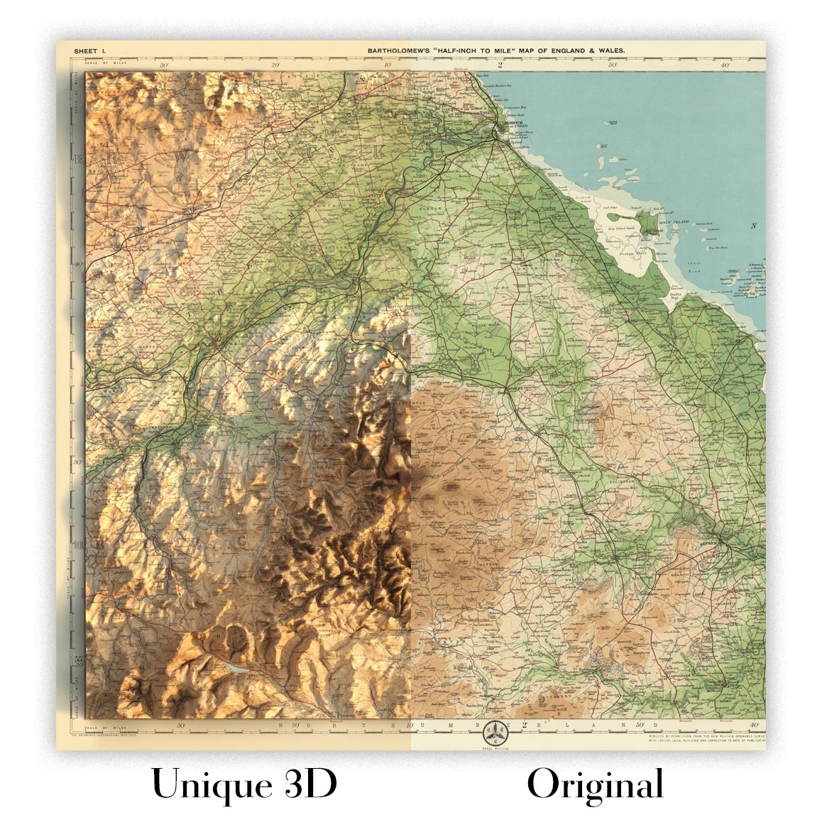
For something truly unique, this map is also available in "Unique 3D", our trademarked process that dramatically transforms the map so that it has a wonderful sense of depth. We combine the original map with detailed topography and elevation data, so that mountains and the terrain really "pop". For more info and examples of 3D maps, check my Unique 3D page.
Many of our maps and art prints are chosen as thoughtful gifts for homes, offices, studies and meaningful places.
Choose a framed option for the easiest ready-to-hang gift, or choose an unframed print if the recipient may prefer to select their own frame.
We make orders locally in 23 countries around the world, so gifts can often be produced close to the recipient. This helps them arrive faster, travel more safely, and avoid customs or import duty surprises.
- We can deliver directly to the recipient
- Framed pieces arrive ready to hang
- Unframed prints are carefully packed in a strong protective tube
- Almost every order is made locally, for faster, safer gifting
- 90-day returns give the recipient time to decide
If you are not sure what to choose, please contact us. We can help you pick the right map, size, finish or delivery option.
Para la mayoría de los pedidos, el tiempo de entrega es de aproximadamente 3 días laborables. Los productos personalizados y a medida tardan más, ya que tengo que hacer la personalización y enviártelo para su aprobación, lo cual suele tardar 1 o 2 días.
Tenga en cuenta que los pedidos enmarcados muy grandes suelen tardar más en fabricarse y entregarse.
Si necesitas que tu pedido llegue para una fecha determinada, por favor contáctame antes de hacer el pedido para que podamos encontrar la mejor manera de asegurarnos de que recibas tu pedido a tiempo.
Imprimo y enmarco mapas y obras de arte en 23 países alrededor del mundo. Esto significa que tu pedido se fabricará localmente, lo que reduce el tiempo de entrega y asegura que no se dañe durante el envío. Nunca pagarás aranceles de aduana o impuestos de importación, y pondremos menos CO2 en el aire.
Todos mis mapas y impresiones artísticas están bien empaquetados y enviados en un tubo resistente si no están enmarcados, o rodeados de espuma si están enmarcados.
Intento enviar todos los pedidos dentro de 1 o 2 días después de recibir tu pedido, aunque algunos productos (como mascarillas, tazas y bolsas de tela) pueden tardar más en fabricarse.
Si seleccionas Entrega Exprés al finalizar la compra, priorizaremos tu pedido y lo enviaremos por mensajería de 1 día (Fedex, DHL, UPS, Parcelforce).
La entrega al día siguiente también está disponible en algunos países (EE. UU., Reino Unido, Singapur, EAU), pero por favor intenta hacer tu pedido temprano en el día para que podamos enviarlo a tiempo.
Mi marco estándar es un marco de madera de fresno negro estilo galería. Es simple y tiene un aspecto bastante moderno. Mi marco estándar tiene alrededor de 20 mm (0.8 in) de ancho.
Utilizo acrílico super claro (perspex/acrylite) para el vidrio del marco. Es más ligero y seguro que el vidrio, y se ve mejor, ya que la reflectividad es menor.
Seis colores de marco estándar están disponibles de forma gratuita (negro, marrón oscuro, gris oscuro, roble, blanco y oro antiguo).El enmarcado y montaje/matizado personalizado está disponible si buscas algo diferente.
La mayoría de los mapas, arte e ilustraciones también están disponibles como un lienzo enmarcado. Utilizamos lienzo de algodón mate (no brillante), lo estiramos sobre un marco de madera de caja de origen sostenible, y luego 'flotamos' la pieza dentro de un marco de madera. El resultado final es bastante hermoso, y no hay cristal que se interponga.
Todos los marcos se proporcionan "listos para colgar", con una cuerda o soportes en la parte posterior. Los marcos muy grandes tendrán placas de colgar de alta resistencia y/o un listón de montaje. Si tienes alguna pregunta, por favor ponte en contacto.
Mira algunos ejemplos de mis mapas enmarcados y mapas en lienzo enmarcados.
Alternativamente, también puedo proporcionar mapas antiguos y obras de arte en lienzo, tablero de espuma, papel de algodón y otros materiales.
Si deseas enmarcar tu mapa o obra de arte tú mismo, por favor lee mi guía de tamaños primero.
Mis mapas son reproducciones de mapas originales de altísima calidad.
Obtengo mapas originales y raros de bibliotecas, casas de subastas y colecciones privadas de todo el mundo, los restauro en mi taller de Londres y luego uso tintas e impresoras giclée especializadas para crear hermosos mapas que lucen incluso mejor que el original.
Mis mapas están impresos en papel de archivo mate (no brillante) sin ácido que se siente de muy alta calidad y casi como una tarjeta. En términos técnicos, el peso/grosor del papel es de 10 mil/200 g/m². Es perfecto para enmarcar.
Imprimo con tintas pigmentadas Epson ultrachrome giclée UV resistentes a la decoloración, algunas de las mejores tintas que puedes encontrar.
yo también puedo hacer mapas sobre lienzo, trapo de algodón y otros materiales exóticos.
Obtenga más información sobre The Unique Maps Co..
Personalización de mapas
Si está buscando el regalo perfecto de aniversario o inauguración de la casa, puedo personalizar su mapa para hacerlo verdaderamente único. Por ejemplo, puedo agregar un mensaje corto, resaltar una ubicación importante o agregar el escudo de armas de su familia.
Las opciones son casi infinitas. Por favor mira mi página de personalización de mapas para ver algunos maravillosos ejemplos de lo que es posible.
Para pedir un mapa personalizado, seleccione "personalizar su mapa" antes de agregarlo a su carrito.
Ponerse en contacto si buscas personalizaciones y personalizaciones más complejas.
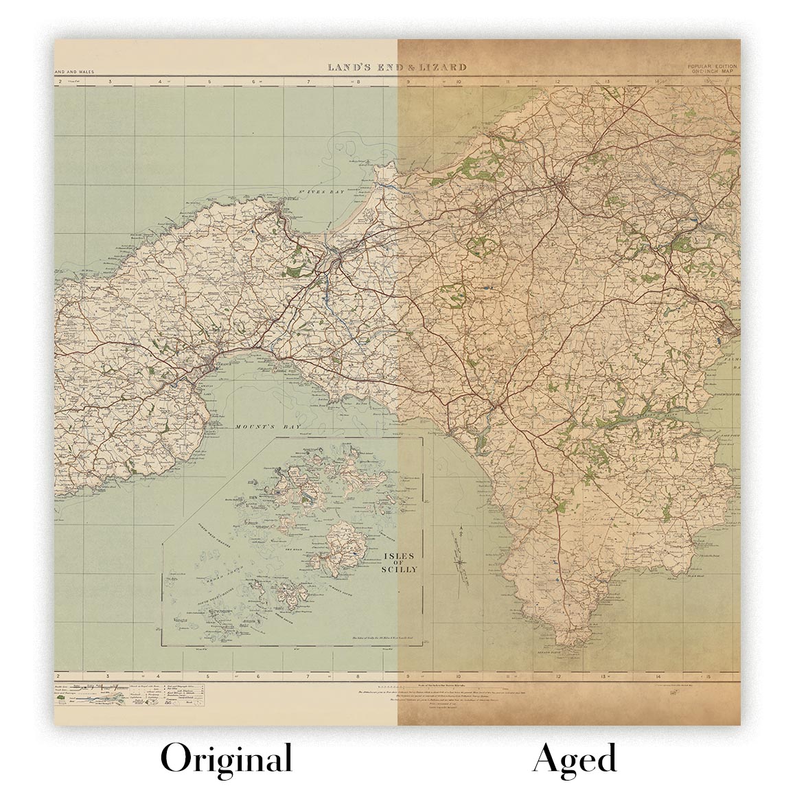
Envejecimiento del mapa
A lo largo de los años, los clientes me han preguntado cientos de veces si podían comprar un mapa que se viera uniforme. más viejo.
Bueno, ahora puedes hacerlo seleccionando Envejecido antes de agregar un mapa a tu carrito.
Todas las fotografías de productos que ve en esta página muestran el mapa en su forma original. Así es como se ve el mapa hoy.
Si selecciona Envejecido, envejeceré su mapa a mano, usando un proceso especial y único desarrollado a través de años de estudiar mapas antiguos, hablar con investigadores para comprender la química del envejecimiento del papel y, por supuesto... ¡mucha práctica!
Si no estás seguro, quédate con el color original del mapa. Si quieres algo un poco más oscuro y más viejo buscando, opte por Envejecido.
Si no estás satisfecho con tu pedido por cualquier motivo, contáctame para un reembolso sin complicaciones. Por favor, consulta nuestra política de devoluciones y reembolsos para más información.
Estoy muy seguro de que te gustará tu mapa o impresión artística restaurada. He estado haciendo esto desde 1984. Soy un vendedor de 5 estrellas en Etsy. He vendido decenas de miles de mapas e impresiones artísticas y tengo más de 5,000 opiniones reales de 5 estrellas.
Utilizo un proceso único para restaurar mapas y obras de arte que consume mucho tiempo y mano de obra. Buscar los mapas e ilustraciones originales puede llevar meses. Utilizo tecnología de última generación y extremadamente cara para escanear y restaurarlos. Como resultado, garantizo que mis mapas e impresiones artísticas son superiores a los demás - por eso puedo ofrecer un reembolso sin complicaciones.
Casi todos mis mapas e impresiones artísticas se ven increíbles en tamaños grandes (200cm, 6.5ft+) y también puedo enmarcarlos y entregártelos a través de un servicio de mensajería especial para tamaños grandes. Contáctame para discutir tus necesidades específicas.
Or try searching for something!


