


Mapa raro del viaje de Abraham en Tierra Santa por Ortelius, 1624: Jerusalén, Ur, Babilonia, Mar Muerto, Mediterráneo
La oferta del coleccionista
Elija dos obras elegibles y obtenga un 20 % de descuento en ambas. Elija tres y la de menor precio será gratuita, con un ahorro máximo del 33 %.
Combine y mezcle mapas estándar elegibles y reproducciones de bellas artes. No se requiere código; la oferta se aplica automáticamente al finalizar la compra.
Se incluyen las configuraciones estándar hechas por encargo. Quedan excluidos los tamaños a medida, los diseños personalizados y los trabajos por encargo.
¿Necesita entrega en diferentes direcciones? Contáctenos antes de realizar el pedido.La oferta del coleccionista
Elija dos obras elegibles y obtenga un 20 % de descuento en ambas. Elija tres y la de menor precio será gratuita, con un ahorro máximo del 33 %.
Combine y mezcle mapas estándar elegibles y reproducciones de bellas artes. No se requiere código; la oferta se aplica automáticamente al finalizar la compra.
Se incluyen las configuraciones estándar hechas por encargo. Quedan excluidos los tamaños a medida, los diseños personalizados y los trabajos por encargo.
¿Necesita entrega en diferentes direcciones? Contáctenos antes de realizar el pedido. Diseñado en Londres Hecho en Canada
Diseñado en Londres • Hecho en Canada
Diseñado en Londres Hecho en Canada
Diseñado en Londres • Hecho en Canada

Restaurado a partir del mapa original de 1624 e impreso en calidad museo. Leer la historia detrás de este mapa
Choose your size
Choose your finish


(Más información)
Mensaje de regalo y acabado personalizado

Si deseas agregar un mensaje de regalo, o un acabado (rompecabezas, tablero de aluminio, etc.) que no esté disponible aquí, por favor solicítalo en la "nota del pedido" cuando realices la compra.
Cada pedido es hecho a medida, así que si necesitas que el tamaño se ajuste ligeramente, o que se imprima en un material inusual, háznoslo saber. Hemos realizado miles de pedidos personalizados a lo largo de los años, así que hay (casi) nada que no podamos gestionar.
También puedes contactarnos antes de hacer tu pedido, ¡si lo prefieres!

- Hecho localmente. Entrega segura
- Sin aranceles ni cargos ocultos
- ¿Necesitas ayuda? Llámanos o mensaje por WhatsApp
Own a piece of history
8,000+ five-star reviews


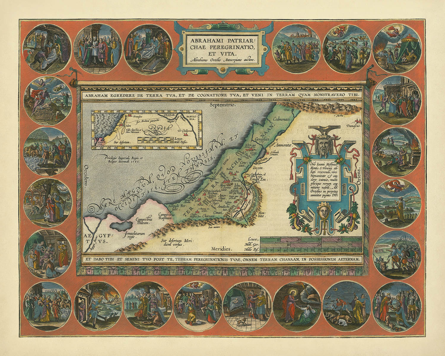
Adéntrese en el mundo de la antigüedad bíblica con la obra maestra de Abraham Ortelius, Abrahami Patriarchae Peregrinatio Et Vita, un mapa...
Seguir leyendoAdéntrese en el mundo de la antigüedad bíblica con la obra maestra de Abraham Ortelius, Abrahami Patriarchae Peregrinatio Et Vita, un mapa que se erige a la vez como un logro cartográfico y una crónica visual del legendario viaje del patriarca Abraham. Elaborado en 1624 por el eminente cartógrafo flamenco, este mapa es un testimonio de la dedicación de Ortelius a combinar la precisión geográfica con la narración histórica. El título original en latín, que se traduce como “Los viajes y la vida de Abraham el patriarca”, prepara el escenario para una odisea pictórica por las tierras que dieron forma a las historias más perdurables del mundo antiguo.
Ortelius, célebre por su innovador Theatrum Orbis Terrarum, convirtió su fascinación personal por la historia clásica y bíblica en el Parergon, el primer atlas histórico del mundo. Este mapa, uno de los más elaborados de la serie, ejemplifica su rara capacidad para combinar arte y erudición. Cada detalle está minuciosamente representado, desde los fluidos contornos del río Jordán hasta las escarpadas cumbres del monte Líbano, invitando al espectador a seguir las huellas de Abraham a través de la cuna de la civilización. Los elementos decorativos del mapa —ornamentos cartográficos elaborados, elegante rosa de los vientos e intrincados bordes— reflejan la համոզción de Ortelius de que los mapas deben inspirar tanto como informar.
El corazón de este mapa reside en su vívida narración. Veintidós viñetas en medallón rodean el campo cartográfico principal, y cada una captura un momento decisivo de la vida de Abraham: su partida de Ur, sus encuentros en Canaán, el drama del casi sacrificio de Isaac, y más. Estas escenas narrativas transforman el mapa en un tapiz viviente, donde la geografía y la leyenda se entrelazan. La Tierra Santa está representada con extraordinario cuidado, con sus antiguas regiones —Canaán, Judea y más allá— claramente delimitadas, mientras que el mar Mediterráneo, el mar Muerto y el mar de Galilea anclan el paisaje en una forma reconocible.
Más allá de su resonancia bíblica, el mapa es una ventana al mundo interconectado de comienzos del siglo XVII. Ciudades y poblaciones como Jerusalén, Hebrón, Damasco y Babilonia aparecen junto a las célebres ruinas de Ur y Menfis, ofreciendo una rara convergencia de mito e historia. El mapa enlaza continentes, conectando el Levante con el valle del Nilo, Mesopotamia y Anatolia, y nos recuerda las antiguas rutas comerciales y los intercambios culturales que antaño fluyeron por estas tierras. Cada asentamiento es un hito en el viaje de Abraham y un testimonio del compromiso de Ortelius con la precisión histórica.
Poseer este mapa es poseer una pieza del legado cartográfico: una síntesis de la curiosidad intelectual, la maestría artística y la reverencia por el pasado de Ortelius. No es meramente una representación de la Tierra Santa; es una epopeya visual que invita al espectador contemporáneo a contemplar los paisajes que dieron forma a la fe, la historia y la imaginación humana. Con su intrincado detalle y su profunda narrativa, Abrahami Patriarchae Peregrinatio Et Vita es un tesoro para coleccionistas y conocedores que buscan las expresiones más raras de la historia y el arte.
Ciudades y poblaciones en este mapa
- Israel actual:
- Jerusalén
- Hebrón
- Beerseba
- Betel
- Siquem (Nablus)
- Dan
- Líbano actual:
- Sidón (Saida)
- Tiro (Sour)
- Siria actual:
- Damasco
- Iraq actual:
- Babilonia (cerca de la actual Hillah)
- Ur (cerca de la actual Nasiriyah)
- Egipto actual:
- Menfis (cerca del Cairo actual)
- Turquía actual:
- Harrán (Harran)
Características y hitos notables
- 22 viñetas medallón detalladas que representan escenas clave de la vida de Abraham
- Mar Mediterráneo ("Mare Magnum")
- Mar Muerto ("Lacus Asphaltites")
- Mar de Galilea ("Mare Galileae")
- Río Jordán ("Iordanis Fluvius")
- Destacadas cadenas montañosas y colinas, incluido el monte Líbano ("Libanus Mons")
- Regiones y territorios claramente delimitados de tribus y pueblos históricos, como Canaán y Judea
- Cartelas ornamentadas y bordes elaborados
- Rosa de los vientos decorativa
Contexto histórico y de diseño
- Realizado en 1624 por Abraham Ortelius, célebre cartógrafo flamenco y creador del primer atlas moderno
- Título original: Abrahami Patriarchae Peregrinatio Et Vita (Tierra Santa / Viajes de Abraham)
- Parte del Parergon de Ortelius, el primer atlas histórico y un proyecto que consideraba su mayor logro
- El mapa ilustra la vida y los viajes del patriarca bíblico Abraham, combinando precisión geográfica con una rica narrativa histórica
- Cada mapa del Parergon fue dibujado a mano por Ortelius, reflejando su profunda curiosidad por la antigüedad clásica y la historia bíblica
- El mapa destaca por sus adornos artísticos y su detallada narración mediante elementos pictóricos
Por favor, revise las imágenes cuidadosamente para asegurarse de que una ciudad o lugar específico aparezca en este mapa. También puede ponerse en contacto con nosotros y pedirnos que lo comprobemos por usted.
Este mapa se ve magnífico en cualquier tamaño, pero siempre recomiendo optar por un tamaño mayor si dispone de espacio. Así podrá apreciar fácilmente todos los detalles.
Este mapa luce increíble en tamaños de hasta 70in (180cm). Si está buscando un mapa más grande, por favor póngase en contacto.
La modelo de las imágenes del anuncio sostiene la versión de 16x20in (40x50cm) de este mapa.
La quinta imagen del anuncio muestra un ejemplo de mi servicio de personalización de mapas.
Si busca algo ligeramente diferente, consulte mi colección de los mejores mapas antiguos para ver si algo más le llama la atención.
Por favor, contácteme para comprobar si una determinada ubicación, hito o elemento aparece en este mapa.
Sería un regalo maravilloso de cumpleaños, Navidad, Día del Padre, despedida laboral, aniversario o inauguración de casa para alguien de las zonas cubiertas por este mapa.
Este mapa está disponible como impresión giclée en papel mate de archivo libre de ácido, o puede adquirirlo enmarcado. El marco es un bonito y sencillo marco negro que se adapta a la mayoría de las estéticas. Por favor, póngase en contacto si desea un color o material de marco diferente. Mis marcos están acristalados con acrílico de calidad museística de gran transparencia (perspex/acrylite), que es significativamente menos reflectante que el vidrio, más seguro y siempre llegará en perfectas condiciones.
This map is also available as a float framed canvas, sometimes known as a shadow gap framed canvas or canvas floater. The map is printed on artist's cotton canvas and then stretched over a handmade box frame. We then "float" the canvas inside a wooden frame, which is available in a range of colours (black, dark brown, oak, antique gold and white). This is a wonderful way to present a map without glazing in front. See some examples of float framed canvas maps and explore the differences between my different finishes.
For something truly unique, this map is also available in "Unique 3D", our trademarked process that dramatically transforms the map so that it has a wonderful sense of depth. We combine the original map with detailed topography and elevation data, so that mountains and the terrain really "pop". For more info and examples of 3D maps, check my Unique 3D page.
Adéntrese en el mundo de la antigüedad bíblica con la obra maestra de Abraham Ortelius, Abrahami Patriarchae Peregrinatio Et Vita, un mapa que se erige a la vez como un logro cartográfico y una crónica visual del legendario viaje del patriarca Abraham. Elaborado en 1624 por el eminente cartógrafo flamenco, este mapa es un testimonio de la dedicación de Ortelius a combinar la precisión geográfica con la narración histórica. El título original en latín, que se traduce como “Los viajes y la vida de Abraham el patriarca”, prepara el escenario para una odisea pictórica por las tierras que dieron forma a las historias más perdurables del mundo antiguo.
Ortelius, célebre por su innovador Theatrum Orbis Terrarum, convirtió su fascinación personal por la historia clásica y bíblica en el Parergon, el primer atlas histórico del mundo. Este mapa, uno de los más elaborados de la serie, ejemplifica su rara capacidad para combinar arte y erudición. Cada detalle está minuciosamente representado, desde los fluidos contornos del río Jordán hasta las escarpadas cumbres del monte Líbano, invitando al espectador a seguir las huellas de Abraham a través de la cuna de la civilización. Los elementos decorativos del mapa —ornamentos cartográficos elaborados, elegante rosa de los vientos e intrincados bordes— reflejan la համոզción de Ortelius de que los mapas deben inspirar tanto como informar.
El corazón de este mapa reside en su vívida narración. Veintidós viñetas en medallón rodean el campo cartográfico principal, y cada una captura un momento decisivo de la vida de Abraham: su partida de Ur, sus encuentros en Canaán, el drama del casi sacrificio de Isaac, y más. Estas escenas narrativas transforman el mapa en un tapiz viviente, donde la geografía y la leyenda se entrelazan. La Tierra Santa está representada con extraordinario cuidado, con sus antiguas regiones —Canaán, Judea y más allá— claramente delimitadas, mientras que el mar Mediterráneo, el mar Muerto y el mar de Galilea anclan el paisaje en una forma reconocible.
Más allá de su resonancia bíblica, el mapa es una ventana al mundo interconectado de comienzos del siglo XVII. Ciudades y poblaciones como Jerusalén, Hebrón, Damasco y Babilonia aparecen junto a las célebres ruinas de Ur y Menfis, ofreciendo una rara convergencia de mito e historia. El mapa enlaza continentes, conectando el Levante con el valle del Nilo, Mesopotamia y Anatolia, y nos recuerda las antiguas rutas comerciales y los intercambios culturales que antaño fluyeron por estas tierras. Cada asentamiento es un hito en el viaje de Abraham y un testimonio del compromiso de Ortelius con la precisión histórica.
Poseer este mapa es poseer una pieza del legado cartográfico: una síntesis de la curiosidad intelectual, la maestría artística y la reverencia por el pasado de Ortelius. No es meramente una representación de la Tierra Santa; es una epopeya visual que invita al espectador contemporáneo a contemplar los paisajes que dieron forma a la fe, la historia y la imaginación humana. Con su intrincado detalle y su profunda narrativa, Abrahami Patriarchae Peregrinatio Et Vita es un tesoro para coleccionistas y conocedores que buscan las expresiones más raras de la historia y el arte.
Ciudades y poblaciones en este mapa
- Israel actual:
- Jerusalén
- Hebrón
- Beerseba
- Betel
- Siquem (Nablus)
- Dan
- Líbano actual:
- Sidón (Saida)
- Tiro (Sour)
- Siria actual:
- Damasco
- Iraq actual:
- Babilonia (cerca de la actual Hillah)
- Ur (cerca de la actual Nasiriyah)
- Egipto actual:
- Menfis (cerca del Cairo actual)
- Turquía actual:
- Harrán (Harran)
Características y hitos notables
- 22 viñetas medallón detalladas que representan escenas clave de la vida de Abraham
- Mar Mediterráneo ("Mare Magnum")
- Mar Muerto ("Lacus Asphaltites")
- Mar de Galilea ("Mare Galileae")
- Río Jordán ("Iordanis Fluvius")
- Destacadas cadenas montañosas y colinas, incluido el monte Líbano ("Libanus Mons")
- Regiones y territorios claramente delimitados de tribus y pueblos históricos, como Canaán y Judea
- Cartelas ornamentadas y bordes elaborados
- Rosa de los vientos decorativa
Contexto histórico y de diseño
- Realizado en 1624 por Abraham Ortelius, célebre cartógrafo flamenco y creador del primer atlas moderno
- Título original: Abrahami Patriarchae Peregrinatio Et Vita (Tierra Santa / Viajes de Abraham)
- Parte del Parergon de Ortelius, el primer atlas histórico y un proyecto que consideraba su mayor logro
- El mapa ilustra la vida y los viajes del patriarca bíblico Abraham, combinando precisión geográfica con una rica narrativa histórica
- Cada mapa del Parergon fue dibujado a mano por Ortelius, reflejando su profunda curiosidad por la antigüedad clásica y la historia bíblica
- El mapa destaca por sus adornos artísticos y su detallada narración mediante elementos pictóricos
Por favor, revise las imágenes cuidadosamente para asegurarse de que una ciudad o lugar específico aparezca en este mapa. También puede ponerse en contacto con nosotros y pedirnos que lo comprobemos por usted.
Este mapa se ve magnífico en cualquier tamaño, pero siempre recomiendo optar por un tamaño mayor si dispone de espacio. Así podrá apreciar fácilmente todos los detalles.
Este mapa luce increíble en tamaños de hasta 70in (180cm). Si está buscando un mapa más grande, por favor póngase en contacto.
La modelo de las imágenes del anuncio sostiene la versión de 16x20in (40x50cm) de este mapa.
La quinta imagen del anuncio muestra un ejemplo de mi servicio de personalización de mapas.
Si busca algo ligeramente diferente, consulte mi colección de los mejores mapas antiguos para ver si algo más le llama la atención.
Por favor, contácteme para comprobar si una determinada ubicación, hito o elemento aparece en este mapa.
Sería un regalo maravilloso de cumpleaños, Navidad, Día del Padre, despedida laboral, aniversario o inauguración de casa para alguien de las zonas cubiertas por este mapa.
Este mapa está disponible como impresión giclée en papel mate de archivo libre de ácido, o puede adquirirlo enmarcado. El marco es un bonito y sencillo marco negro que se adapta a la mayoría de las estéticas. Por favor, póngase en contacto si desea un color o material de marco diferente. Mis marcos están acristalados con acrílico de calidad museística de gran transparencia (perspex/acrylite), que es significativamente menos reflectante que el vidrio, más seguro y siempre llegará en perfectas condiciones.
This map is also available as a float framed canvas, sometimes known as a shadow gap framed canvas or canvas floater. The map is printed on artist's cotton canvas and then stretched over a handmade box frame. We then "float" the canvas inside a wooden frame, which is available in a range of colours (black, dark brown, oak, antique gold and white). This is a wonderful way to present a map without glazing in front. See some examples of float framed canvas maps and explore the differences between my different finishes.
For something truly unique, this map is also available in "Unique 3D", our trademarked process that dramatically transforms the map so that it has a wonderful sense of depth. We combine the original map with detailed topography and elevation data, so that mountains and the terrain really "pop". For more info and examples of 3D maps, check my Unique 3D page.
Many of our maps and art prints are chosen as thoughtful gifts for homes, offices, studies and meaningful places.
Choose a framed option for the easiest ready-to-hang gift, or choose an unframed print if the recipient may prefer to select their own frame.
We make orders locally in 23 countries around the world, so gifts can often be produced close to the recipient. This helps them arrive faster, travel more safely, and avoid customs or import duty surprises.
- We can deliver directly to the recipient
- Framed pieces arrive ready to hang
- Unframed prints are carefully packed in a strong protective tube
- Almost every order is made locally, for faster, safer gifting
- 90-day returns give the recipient time to decide
If you are not sure what to choose, please contact us. We can help you pick the right map, size, finish or delivery option.
Para la mayoría de los pedidos, el tiempo de entrega es de aproximadamente 3 días laborables. Los productos personalizados y a medida tardan más, ya que tengo que hacer la personalización y enviártelo para su aprobación, lo cual suele tardar 1 o 2 días.
Tenga en cuenta que los pedidos enmarcados muy grandes suelen tardar más en fabricarse y entregarse.
Si necesitas que tu pedido llegue para una fecha determinada, por favor contáctame antes de hacer el pedido para que podamos encontrar la mejor manera de asegurarnos de que recibas tu pedido a tiempo.
Imprimo y enmarco mapas y obras de arte en 23 países alrededor del mundo. Esto significa que tu pedido se fabricará localmente, lo que reduce el tiempo de entrega y asegura que no se dañe durante el envío. Nunca pagarás aranceles de aduana o impuestos de importación, y pondremos menos CO2 en el aire.
Todos mis mapas y impresiones artísticas están bien empaquetados y enviados en un tubo resistente si no están enmarcados, o rodeados de espuma si están enmarcados.
Intento enviar todos los pedidos dentro de 1 o 2 días después de recibir tu pedido, aunque algunos productos (como mascarillas, tazas y bolsas de tela) pueden tardar más en fabricarse.
Si seleccionas Entrega Exprés al finalizar la compra, priorizaremos tu pedido y lo enviaremos por mensajería de 1 día (Fedex, DHL, UPS, Parcelforce).
La entrega al día siguiente también está disponible en algunos países (EE. UU., Reino Unido, Singapur, EAU), pero por favor intenta hacer tu pedido temprano en el día para que podamos enviarlo a tiempo.
Mi marco estándar es un marco de madera de fresno negro estilo galería. Es simple y tiene un aspecto bastante moderno. Mi marco estándar tiene alrededor de 20 mm (0.8 in) de ancho.
Utilizo acrílico super claro (perspex/acrylite) para el vidrio del marco. Es más ligero y seguro que el vidrio, y se ve mejor, ya que la reflectividad es menor.
Seis colores de marco estándar están disponibles de forma gratuita (negro, marrón oscuro, gris oscuro, roble, blanco y oro antiguo).El enmarcado y montaje/matizado personalizado está disponible si buscas algo diferente.
La mayoría de los mapas, arte e ilustraciones también están disponibles como un lienzo enmarcado. Utilizamos lienzo de algodón mate (no brillante), lo estiramos sobre un marco de madera de caja de origen sostenible, y luego 'flotamos' la pieza dentro de un marco de madera. El resultado final es bastante hermoso, y no hay cristal que se interponga.
Todos los marcos se proporcionan "listos para colgar", con una cuerda o soportes en la parte posterior. Los marcos muy grandes tendrán placas de colgar de alta resistencia y/o un listón de montaje. Si tienes alguna pregunta, por favor ponte en contacto.
Mira algunos ejemplos de mis mapas enmarcados y mapas en lienzo enmarcados.
Alternativamente, también puedo proporcionar mapas antiguos y obras de arte en lienzo, tablero de espuma, papel de algodón y otros materiales.
Si deseas enmarcar tu mapa o obra de arte tú mismo, por favor lee mi guía de tamaños primero.
Mis mapas son reproducciones de mapas originales de altísima calidad.
Obtengo mapas originales y raros de bibliotecas, casas de subastas y colecciones privadas de todo el mundo, los restauro en mi taller de Londres y luego uso tintas e impresoras giclée especializadas para crear hermosos mapas que lucen incluso mejor que el original.
Mis mapas están impresos en papel de archivo mate (no brillante) sin ácido que se siente de muy alta calidad y casi como una tarjeta. En términos técnicos, el peso/grosor del papel es de 10 mil/200 g/m². Es perfecto para enmarcar.
Imprimo con tintas pigmentadas Epson ultrachrome giclée UV resistentes a la decoloración, algunas de las mejores tintas que puedes encontrar.
yo también puedo hacer mapas sobre lienzo, trapo de algodón y otros materiales exóticos.
Obtenga más información sobre The Unique Maps Co..
Personalización de mapas
Si está buscando el regalo perfecto de aniversario o inauguración de la casa, puedo personalizar su mapa para hacerlo verdaderamente único. Por ejemplo, puedo agregar un mensaje corto, resaltar una ubicación importante o agregar el escudo de armas de su familia.
Las opciones son casi infinitas. Por favor mira mi página de personalización de mapas para ver algunos maravillosos ejemplos de lo que es posible.
Para pedir un mapa personalizado, seleccione "personalizar su mapa" antes de agregarlo a su carrito.
Ponerse en contacto si buscas personalizaciones y personalizaciones más complejas.
Envejecimiento del mapa
A lo largo de los años, los clientes me han preguntado cientos de veces si podían comprar un mapa que se viera uniforme. más viejo.
Bueno, ahora puedes hacerlo seleccionando Envejecido antes de agregar un mapa a tu carrito.
Todas las fotografías de productos que ve en esta página muestran el mapa en su forma original. Así es como se ve el mapa hoy.
Si selecciona Envejecido, envejeceré su mapa a mano, usando un proceso especial y único desarrollado a través de años de estudiar mapas antiguos, hablar con investigadores para comprender la química del envejecimiento del papel y, por supuesto... ¡mucha práctica!
Si no estás seguro, quédate con el color original del mapa. Si quieres algo un poco más oscuro y más viejo buscando, opte por Envejecido.
Si no estás satisfecho con tu pedido por cualquier motivo, contáctame para un reembolso sin complicaciones. Por favor, consulta nuestra política de devoluciones y reembolsos para más información.
Estoy muy seguro de que te gustará tu mapa o impresión artística restaurada. He estado haciendo esto desde 1984. Soy un vendedor de 5 estrellas en Etsy. He vendido decenas de miles de mapas e impresiones artísticas y tengo más de 5,000 opiniones reales de 5 estrellas.
Utilizo un proceso único para restaurar mapas y obras de arte que consume mucho tiempo y mano de obra. Buscar los mapas e ilustraciones originales puede llevar meses. Utilizo tecnología de última generación y extremadamente cara para escanear y restaurarlos. Como resultado, garantizo que mis mapas e impresiones artísticas son superiores a los demás - por eso puedo ofrecer un reembolso sin complicaciones.
Casi todos mis mapas e impresiones artísticas se ven increíbles en tamaños grandes (200cm, 6.5ft+) y también puedo enmarcarlos y entregártelos a través de un servicio de mensajería especial para tamaños grandes. Contáctame para discutir tus necesidades específicas.
Or try searching for something!


